Medieval Arab Naviation
“More interesting is the testimony of Ibn al-Mujawir who reports that in 626 A.H./1228-9 A.D. a ship arrived in Aden from Qumr (Comoros or Madagascar); the art of navigation of the people of Qumr impressed him as superior to that of the Arabs. In fact, the route between Aden, Mogadisho, Kilwa and Qumr, which traditionally is made in three separate sailing periods, these men sailed in one season (mawsim). Ibn al-Mujawir also claims that at an uncertain time in the history of Aden the people of Qumr conquered the original settlement on the peninsula, arriving in outrigger boats (Ibn al-Mujawir calls them <<winged>>) and expelling the natives to the mainland. Clearly, then, the Arabs were familiar not only with the Persian system of navigation, and both the Arabs and Persians had the opportunity to learn from other ocean-faring peoples. The process long predates Ibn al- Mujawir’s narrative for, as he states, “these peoples have died out, and their art with them; travel in this manner has stopped, and in our time there remains no one could relate their circumstances and affairs?”.
This curious lament could hardly refer to a depopulation of Madagascar; rather, it seems, to the loss in the indefinite past of an active tradition of monsoon sailing brought to Madagascar by its Indonesian settlers who may have initially attempted to expand their colonization but were thwarted in their effort and left the domination of the Indian Ocean to the Arabs.
People of Qumr may have been the ones who brought west a system of orientation developed in equatorial waters and suited for east-west journeys – such as their journey to Madagascar, or such as the island migrations in the Pacific. Regardless of what people may have been the originators of such a system, it is improbable that the star compass, which essentially is an extension of the star path method, may have been developed in other circumstances than those of oceanic sailing.”
From a fascinating article by Marina Tomalcheva. (Tomalcheva, Marina. 1980. “On the Arab System of Nautical Orientation” in Arabica 27 (2): 180-192)
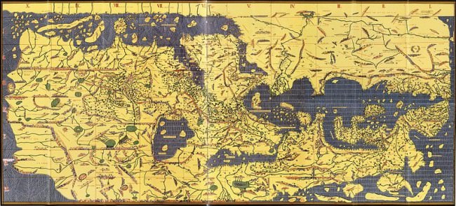
One friend pointed out Sicilian Arab cartographer and geographer Al-Idrisi‘s medieval map of the world in which the Middle East is the centre of the map, and the South is at the top of the map.