Sinews of War and Trade 2018-01-05T16:05:13Z http://sinewswartrade.com/feed/atom/ WordPress Laleh Khalili <![CDATA[Offshore]]> http://thegamming.org/?p=1247 2018-01-05T16:05:13Z 2018-01-05T16:05:13Z In one of the most significant environmental decisions the Trump administration has taken, a ban on offshore drilling was lifted on 4 January 2018.  The New York Times reported:

While the plan puts the administration squarely on the side of the energy industry and against environmental groups, it also puts the White House at odds with a number of coastal states that oppose offshore drilling. Some of those states are led by Republicans, like Gov. Rick Scott of Florida, where the tourism industry was hit hard by the Deepwater Horizon rig disaster in 2010 that killed 11 people and spilled millions of gallons of oil into the Gulf of Mexico. […]

The governors of New Jersey, Delaware, Maryland, Virginia, North Carolina, South Carolina, California, Oregon and Washington have all opposed offshore drilling plans. Virginia’s governor-elect, Ralph S. Northam, a Democrat, said in a statement Thursday that expanding drilling would jeopardize his state’s tourism and fishing industries, as well as military installations. Gov. Roy Cooper of North Carolina, also a Democrat, called drilling a “critical threat” to his state’s economy.

It would be fascinating to see what sorts of controversies and contentions between the states and the federal government may emerge after this decision. Interestingly the designation of “continental shelf” as a legal maritime category emerged in mid-20th century precisely out of such a controversy over whether the states or the federal US government had the right and control of the subsea resources contiguous with a given state.

In September 1945, Harry Truman issued an executive order to declare that the US federal territory extended to the edge of its continental shelf – in order to ensure that the US could drill for oil and gas beneath the sea undeterred. Executive Order 9633, specifically stated that

Having concern for the urgency of conserving and prudently utilizing its natural resources, the Government of the United States regards the natural resources of the subsoil and sea bed of the continental shelf beneath the high seas but contiguous to the coasts of the United States as appertaining to the United States, subject to its jurisdiction and control. In cases where the continental shelf extends to the shores of another State, or is shared with an adjacent State, the boundary shall be determined by the United States and the State concerned in accordance with equitable principles. The character as high seas of the waters above the continental shelf and the right to their free and unimpeded navigation are in no way thus affected.

Only a couple of years after this declaration, the Federal government had to take the state of California to court,

to determine which government owns, or has paramount rights in and power over, the submerged land off the coast of California between the low water mark and the three-mile limit and has a superior right to take or authorize the taking of the vast quantities of oil and gas underneath that land (much of which has already been, and more of which is about to be, taken by or under authority of the State).

As Justice Black wrote in his summary of the case, California, “acting pursuant to state statutes but without authority from the United States, has negotiated and executed numerous leases with persons and corporations purporting to authorize them to enter upon the described ocean area to take petroleum, gas, and other mineral deposits, and that the lessees have done so, paying to California large sums of money in rents and royalties for the petroleum products taken.”

Notably, in deciding the case for the Federal government, the Supreme Court judges invoked the sovereignty of the United States among the family of nations, and even more remarkably, the centrality of security concerns (“protect[ing] this country against dangers to the security and tranquility of its people”).

Tugboats pulling offshore drilling platform Gulf of Mexico 2013

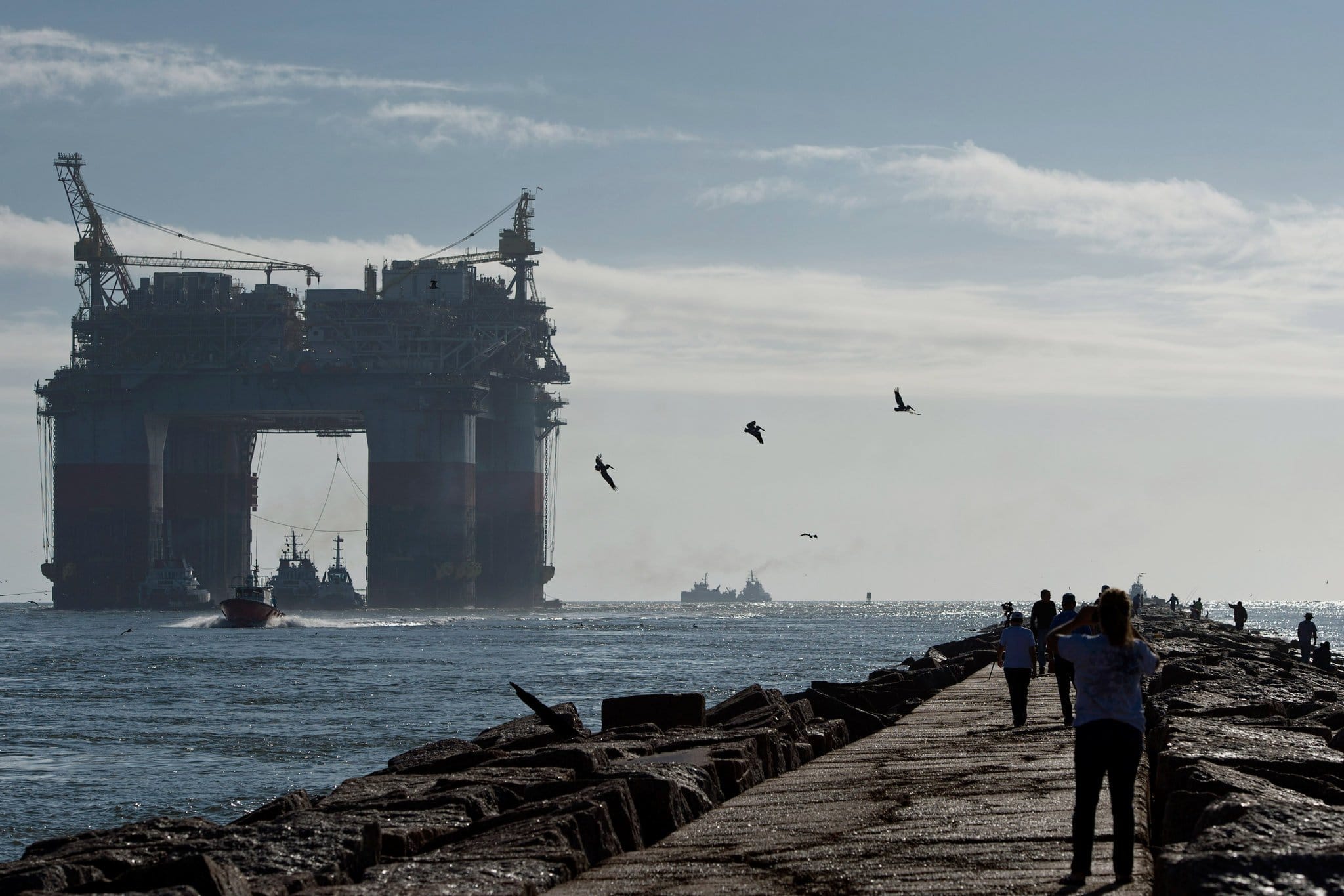
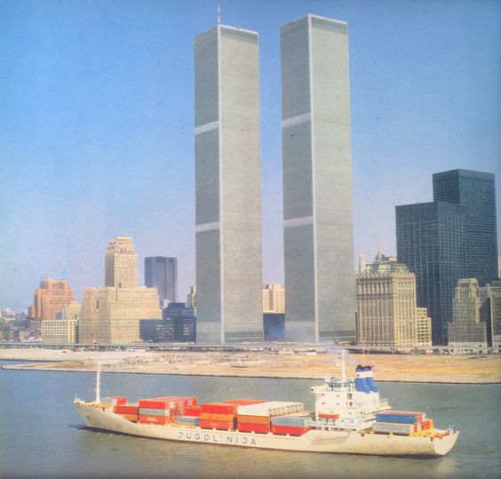
Tugboats pulled a Chevron drilling platform toward the Gulf of Mexico in 2013. The Trump administration said Thursday it would open most of the country’s offshore waters to oil and gas drilling.CreditEddie Seal/Bloomberg, via Getty Images

Court decisions were consolidated via legislation when in 1953, the US Congress enacted the Submerged Lands Act which gave the control of the continental shelf to the federal government (the above act has now been subsumed into the Outer Continental Shelf Act) and was slightly modified by the Energy Policy Act of 2005, which, inter alia, set up a fund for oil spills and passed on some of the profits from the lease of the subsea resources to the coastal states.

Of course all of this has to be seen in light of the Deepwater Horizon disaster of 2010 which led to an immediate moratorium on drilling in the oceans (lasting only a few months), and eventually to the decision made in the last few weeks of Obama’s time in office to ban these offshore drilling licenses in the Atlantic and in the Arctic.

As the New York Times article reports, the Trump administration repeal of the ban on offshore drilling is part of a larger GOP plan to roll back even the most anaemic environmental legislation in order to facilitate further mineral exploration:

Last month Congress opened the Arctic National Wildlife Refuge, or ANWR, to oil and gas drilling as part of the tax overhaul. And last week the Interior Department rescinded an Obama-era rule that would have added regulations for hydraulic fracturing, or fracking, on federal and tribal lands. It also repealed offshore drilling safety regulations that were put in place after the Deepwater Horizon spill.

Whether there will be takers for the new Atlantic offshore licenses, however, remains to be seen. The low price of oil is a concern for the oil companies wanting to make investments in capital-intensive exploration.  However, people who see the expansion of petroleum exploration and opening up of new fields as a form of “energy independence” for the US (really a nativist fantasy) may want to pay attention to who the investors in the new oil exploration ventures (and especially fracking operations) are.  Forbes reported in September 2016 that Saudi Arabia has been buying into refineries in the US (like many other Gulf countries), while in December 2017, the Wall Street Journal reported that Saudi Arabia was looking to invest in US shale oil (and fracking). Of course the US oil industry, both upstream and downstream, is fully internationalised, so it is not at all surprising that the Saudis, like Qataris, Kuwaitis, the British, Dutch, Chinese and others have invested in these industries. But it is possible that if there is a legal fight coming over offshore exploration licenses, the players may end up being more and other than the states and federal government, I suspect.

]]>
0
Laleh Khalili <![CDATA[Religious fable about infrastructure]]> http://thegamming.org/?p=1239 2017-10-20T07:00:29Z 2017-10-20T07:00:29Z Source: Siyar al-Muluk by Nizam al-Mulk (died, 1092). Translation by Navīd Zarrinnal:

“”They say when Umar was about to leave this world, his son asked him: “When will I see you?”
Umar replied: “In the next world.”
His son said: “I want to see you sooner.”
Replied: “the first night, after my death, or on the second or third night, you shall see me in your dream.”

Twelve years passed but no dream of his father came to the son, until one night. In the dream, he asked: “Father, didn’t you say I would see you in the first three nights?”

Umar replied: “A Baghdad bridge was damaged and the officials responsible had not repaired it; sheep were passing and one fell upon a hole and broke his leg. For twelve years now, I was held to account.””

گویند عبدالله بن عمر بن خطاب، به وقت بیرون رفتن پدرش از دنیا، عمر بن خطاب، رضی الله عنه، پرسید که “ای پدر ترا کی بینم؟”
گفت: “بدان جهان!”
گفت: “زودتر می خواهم.”
گفت: ” شب اول یا شب دوم یا شب سوم، مرا در خواب بینی.”
دوازده سال برآمد که او را به خواب ندید. پس از دوازده سال به خواب دید. گفت: “یا پدر نگفته بودی که پسِ سه شب ترا بینم؟”
گفت:” مشغول بودم که در سواد بغداد پلی بیران(خراب) شده بود و گماشتگان تیمارِ آبادان کردن آن نداشته بودند. گوسفندان بر آن می گذشتند. گوسفندی را بر آن پل دست به سوراخی فروشد و بشکست. تا اکنون جواب آن می دادم

]]>
0
Laleh Khalili <![CDATA[The use of free ports to stash arts]]> http://thegamming.org/?p=1228 2017-10-20T06:58:11Z 2017-10-20T06:58:11Z Interesting older item from New York Times on the use of free ports to stash away artworks (and other contraband):

The drab free port zone near the Geneva city center, a compound of blocky gray and vanilla warehouses surrounded by train tracks, roads and a barbed-wire fence, looks like the kind of place where beauty goes to die. But within its walls, crated or sealed cheek by jowl in cramped storage vaults, are more than a million of some of the most exquisite artworks ever made.

[…]

With their controlled climates, confidential record keeping and enormous potential for tax savings, free ports have become the parking lot of choice for high-net-worth buyers looking to round out investment portfolios with art.

[…]

Free ports originated in the 19th century for the temporary storage of goods like grain, tea and industrial goods. In the last few decades, however, a handful of them — including Geneva’s — have increasingly come to operate as storage lockers for the superrich. Located in tax-friendly countries and cities, free ports offer savings and security that collectors and dealers find almost irresistible. (Someone who buys a $50 million painting at auction in New York, for example, is staring at a $4.4 million sales tax bill. Ship it to a free port, and the bill disappears, at least until you decide to bring it back to New York.)

At least four major free ports in Switzerland specialize in storing art and other luxury goods like wine and jewelry, and there are four more — most newly minted — around the world: Singapore (2010); Monaco (2012); Luxembourg (2014); and Newark, Del., (2015).

Concerned by the rapid growth of these private storage spaces and worried that they could become havens for contraband and money laundering, Swiss officials initiated an audit in 2012, the results of which were published two years ago. The results revealed a huge increase in the value of goods stored in some warehouses since 2007, led by an increase in high-value goods like art. Though the audit did not specifically measure the increase in stored artworks, it estimated that there were more than 1.2 million pieces of art in the Geneva Free Port alone, some of which had not left the buildings in decades.


]]>
0
Laleh Khalili <![CDATA[The poetry of medieval maritime travel]]> http://thegamming.org/?p=1207 2017-09-13T14:34:18Z 2017-09-13T14:34:18Z I have been reading Arab navigation manuals and travelogues, and there is such poetry in the navigation manuals in particular. It is the liminality of the navigation texts in particular – between art and science, familiar and wholly other.  I just love the enumeration of the principles of navigation for example, by Ahmad Ibn Majid al-Najdi (who, some say, is the master-navigator who in a fit of drunkenness, revealed the route to India to a disconsolate Vasco de Gama beached in East Africa).  These are:

  • Manazil (lunar mansions)
  • Akhnan (rhumbs)
  • Diyar (routes)
  • Masafat (distances)
  • Bashiyat (latitudes)
  • Qiyas (measurements of the stars)
  • Isharat [coastal and maritime] signs (e.g. tides, currents, landmarks, water colouration etc)
  • Hulul al-Shams wa al-Qamar (revolutions of the sun and the moon)
  • Al ryah wa l-mawasim (winds and seasons)
  • Mawasim al-Bahr (seasons of the sea)
  • Alat al-Safina (the ship’s instruments)
  • Siyasat (politics on board, i.e. relations with the crew and passengers)

I especially love the politics element.  Here is a beautiful passage from Najdi himself:

Know oh reader, that sailing the sea has many principles. Understand them: the first is the knowledge of lunar mansions and rhumbs and routes, distances, bashiyat, latitude measuring, signs (of land), the courses of the sun and moon, the winds and their reasons, and the seasons of the sea, the instruments of the ship. .. It is desirable that you should know about risings and “southings” and the methods of taking latitude measurements and their variations and graduations, the risings and settings of the stars, their latitudes, longitudes and distances and their passing the meridian… It is also desirable that you should know all the coasts and their landfalls and their various guides such as mud, or grass, animals or fish, sea-snakes and winds. You should consider the tides, and the sea currents and the islands on every route… (p. 77)

I also love the sense of wonder in these accounts.  Here is the utterly wonderful and observant Sulayman al-Tajir, an itinerant merchant from Siraf (on the southern coast of what is today Iran), describing a sperm whale in the 9th century AD:

20170913_141201_001.jpg

“This sea” is of course the Indian Ocean. And I love the sense of fear and wonder in the account.  The masterful translator and annotator of Najdi also points out Najdi’s fascination with sea-snakes:

seasnakes.png

Sources for the above:

Al-Najdi, Ahmad b Majid. 1971. Arab Navigation in the Indian Ocean Before the Coming of the Portuguese; being a translation of Kitāb al-Fawāʾid fī uṣūl al-baḥr waʾl-qawāʾid of Aḥmad b. Mājid al-Najdī. Ed. G.R. Tibbetts. London: The Royal Asiatic Society of Great Britain and Ireland.

and

Akhbar al Sin wa’l Hind by Sulayman al-Tajir in  Ahmad, S. Maqbul. 1989. Arabic Classical Accounts of India and China. Shimla: Indian Institute of Advanced Study.

Update: a colleague insists that I better emphasise that the De Gama connection has been totally debunked, since de Gama’s guide was actually a “Gujarati Moor” – which Al Najdi was not!

]]>
2
Laleh Khalili <![CDATA[Medieval Arab Naviation]]> http://thegamming.org/?p=1199 2017-09-11T19:57:12Z 2017-09-11T19:57:12Z “More interesting is the testimony of Ibn al-Mujawir who reports that in 626 A.H./1228-9 A.D. a ship arrived in Aden from Qumr (Comoros or Madagascar); the art of navigation of the people of Qumr impressed him as superior to that of the Arabs. In fact, the route between Aden, Mogadisho, Kilwa and Qumr, which traditionally is made in three separate sailing periods, these men sailed in one season (mawsim). Ibn al-Mujawir also claims that at an uncertain time in the history of Aden the people of Qumr conquered the original settlement on the peninsula, arriving in outrigger boats (Ibn al-Mujawir calls them <<winged>>) and expelling the natives to the mainland. Clearly, then, the Arabs were familiar not only with the Persian system of navigation, and both the Arabs and Persians had the opportunity to learn from other ocean-faring peoples. The process long predates Ibn al- Mujawir’s narrative for, as he states, “these peoples have died out, and their art with them; travel in this manner has stopped, and in our time there remains no one could relate their circumstances and affairs?”.

This curious lament could hardly refer to a depopulation of Madagascar; rather, it seems, to the loss in the indefinite past of an active tradition of monsoon sailing brought to Madagascar by its Indonesian settlers who may have initially attempted to expand their colonization but were thwarted in their effort and left the domination of the Indian Ocean to the Arabs.

People of Qumr may have been the ones who brought west a system of orientation developed in equatorial waters and suited for east-west journeys – such as their journey to Madagascar, or such as the island migrations in the Pacific. Regardless of what people may have been the originators of such a system, it is improbable that the star compass, which essentially is an extension of the star path method, may have been developed in other circumstances than those of oceanic sailing.”

From a fascinating article by Marina Tomalcheva. (Tomalcheva, Marina. 1980. “On the Arab System of Nautical Orientation” in Arabica 27 (2): 180-192)

One friend pointed out Sicilian Arab cartographer and geographer Al-Idrisi‘s medieval map of the world in which the Middle East is the centre of the map, and the South is at the top of the map.


]]>
0
Laleh Khalili <![CDATA[Of Ballast and Land Reclamation]]> http://thegamming.org/?p=1151 2017-04-25T17:26:42Z 2017-04-25T17:26:42Z WTC and containership.jpg

That extraordinary image is from some time in the 1970s, and the container-ship steaming so serenely in Hudson River is a Jugolinija ship belonging to the Yugoslav national shipping line.  What is of course poignant about the image is that neither the shipping line nor the World Trade Center towers exist any longer.  I think the photograph is staged, as I don’t really think that there were any container ports up the Hudson River at that stage (the Chelsea Piers catered to passenger ships).  I first saw this image last weekend in Rijeka (the home port of Jugolinija) in a performance by artists/activists of the art project, Said to Contain.

But what i want to reflect on is the middle ground of the photograph – between the ship and the towers.  That 1970s empty space is today Battery Park City, a dense residential and business area.  And it was built by reclaiming land from Hudson River by dumping the rubble dug up from the foundation excavations of the World Trade Centre.

Land reclamation is of great interest to me because of my interest in ports, and seems to be of increasing interest the world over. For example, here is a link to an article about Singapore’s land reclamation projects:

Once I began looking for reclaimed land, I encountered it everywhere. The five towers of the Marina Bay Financial Center are built on reclaimed land; so is an assortment of parks, wharves and a coastal highway. Beach Road, in the island’s belly, at one time had a self-evident name; now it reads like a wry joke, given how much new land separates it from the ocean. Most of Singapore’s Changi Airport sits on earth where there was once only water. The artist Charles Lim Yi Yong grew up in a kampong, or village, near where work on the airport began in 1975, so his house looked out onto reclaimed land. “It was a wooded area, but if you walked there, the ground would be sand and not soil,” Lim said. “Then you went through this desert space. It felt like I was in ‘The Little Prince.’ ”

Before he turned to art, Lim, now 43, sailed in the 1996 Olympics on the Singapore team. He grew interested in the sea because he sailed, and he sailed because he came from a kampong on the coast. The kampong has long since disappeared, and the coast has changed beyond recognition. Lim’s major creation, “Sea State,” is an anthology of artifacts and installations: videos and charts, buoys and other nautical paraphernalia. Shown at the Venice Biennale two years ago, “Sea State” embodies Lim’s obsession with his country’s transactional relationship with the ocean. His art is a form of urban exploration, roving over, into and around Singapore, studying what few others see: outlying islets, sewage tunnels, buoys, lighthouses, sand barges.


But going back to New York City, a Facebook friend turned me on to this article which lists a few other places in New York City which are built on the rubble of excavations, but also wars. The one site that really interested me is FDR Drive which seems to be built on the war rubble of Bristol and other British cities bombed during the World War Two Blitzkrieg.  Apparently the rubble of those cities was heaved onto ships as ballast and dumped in New York.  The above article links to another article in which Michael Ballaban writes

With nearly 85,000 buildings destroyed, Bristol had lots and lots of rubble. Just plenty of it. And when push came to ballast, the Brits just sort of said “screw it,” I imagine, and heaved the remnants of their homes and their factories and their beautiful churches into the bowels of chugging cargo ships.

They dropped so much rubble there, in fact, that the area near the water’s edge between 23rd street and 34th street came to be known as the “Bristol Basin.”


So, cities become rubble become ballast become waste become foundations for infrastructure.

There is also a(nother) colonial story about ballast.  I often tell the story of this stone in my talks:

Picture1.png

Among the holdings of the British Museum, warehoused in their massive storage among around eight million objects, is a carved dark gravestone inscribed in Hebrew and dated 1333 AD, from the port of Aden in Yemen. The inscription says, “Mayest thou rest in peace until the [redeemer] cometh! (2-6) In the month of Tebeth, in the year 1644 [Seleucid], was gathered in peace to her fathers the worthy, respected woman Madmiyah, the daughter of Se’adyah the son of Abraham (may his memory be blessed)”. The stone was donated to the museum in 1886 by Thomas Holdsworth Newman of the shipping firm Messrs Newman, Hunt & Co.  The stone had been brought over to Britain, however, some 30 years earlier, when it had been used as ballast for a ship sailing from India to Zanzibar and onwards to Britain (I have tried to find what sort of ship this was, but have not yet been successful). The shipping firm itself owned whalers in Newfoundland, owned vineyards in Oporto in Portugal, and traded with Mediterranean ports.

There is much about this object that I would love to note here.  It speaks of a long history of Jewish diasporic existence in Aden, in Yemen.  It bespeaks of an imperial carelessness that plunders gravestones for ballast.  And it points to Aden as a significant, perhaps the most significant, coaling station between Europe and India.  I want to say a few words about ballasts, and then I shall shift to Aden itself.

In his beautiful short reflection on ships’ ballast, Charlie Hailey recalls Joseph Conrad’s obsession with ballast, telling us that ships are either “in cargo” or “in ballast”, where the weight, here of stone, later of coal and still later of seawater, is required to balance the ship when the ship is low on cargo. Landscapes were harvested of ballast, looted clean of sand and shingle and rock.  And although ballast may speak of empty ships, of ships that have delivered their goods in one direction and are now sailing in the opposite direction with their cargo heaved to port, it also speaks of resource extraction in ways that would be considered “unproductive” but which are fundamental to capitalist trade.  This resource extraction transformed landscapes in ways that have been forgotten.  Once a ship arrived in port, ballast had to be discarded and despite laws that prevented the discharging of stone and shingle and sand into the sea, Hailey tells us that “discarded ballast spawned landscapes born of displaced materials from far-flung lands” and ballast islands and hills, this wastage “became infrastructure, with these unwitting spoils of trade repurposed for buildings, roads, and railways.” Today, when seawater from one geography is released in port in another geography, there is much concern about invasive species, about this uncanny mixing of waters, organisms, pollutions.

And the harvesting and dumping of ballast also echoes through the dredging and land reclamation processes that transform landscapes, looting far riverbeds of Myanmar for example for gravel to be poured on the seabeds of Singapore, or of ancient marine topographies ripped up to accommodate ships with deeper draughts. This is crucially important.  The making of ports and transport infrastructure in one place requires the despoliation of another place.  A port in Singapore or Dubai requires the ecological devastation of another country’s riverbeds.


]]>
0
Laleh Khalili <![CDATA[The Multivalence of Infrastructures II – Rail]]> http://thegamming.org/?p=1128 2017-03-28T15:53:05Z 2017-03-28T15:53:05Z I am reading a fascinating article about colonial engineering. Canay Ozden’s fabulous “Pontifex Minimus” is about the British engineer of the Low (or old) Aswan Dam, and the article just drips with all sorts of wonderful quotable sections.  For example, this:

The exportation of engineering practices from the metropole to the colony relied on a rhetoric of universal engineering and social principles. In fact, some of the more severe failures of the British in flood control and land utilisation may be explained by the emergence of a universalist perspective in British engineering in the second half of the nineteenth century. Historian Benjamin Weil argues that the generalist paradigm in British irrigation engineering, which emphasized qualitative observation and interactions with locals, was gradually replaced by the specialist paradigm, which assumed that geographic formations exhibited universal features. Engineers born and trained in England were sent to the colonies to apply lessons learned in Europe, often with little success. As Weil shows, the newly trained British engineers’ resistance to engaging with anecdotal data precluded sound explanations of past floods in the Indus Basin and appropriate measures to prevent further floods. (p. 188)

But the bit that really interested me was this:

Although the terms and logistics of Willcocks’ visit to Mesopotamia are unclear, it is unlikely that the visit had ‘nothing to do with’ politics. In the last years of the nineteenth century, several European powers were pressing the Ottoman Empire for concessions to construct a railway to Baghdad. Willcocks arrived in the region shortly after the Germans received the concession and the well-developed British plans had fallen through. Willcocks was certainly aware of the significance of the sought-after railways. It is because the railway was advancing steadily from the West, he wrote, that the increase in the agricultural wealth of the region had become more important than ever. The railway would also decrease the burden of ship traffic on the Euphrates and the Tigris and ensure that they were exploited for irrigation purposes only. Willcocks argued that his technical consideration of the irrigation potential of the region was sufficient evidence for the companies involved in the railway construction to conduct hydraulic surveys:

As always, I turn to Egypt for an example. In Egypt the railways and canals are designed together; the canals preceding the railways and settling their locations. If such a course be followed in Chaldea, the railways will aid the prosperity of the canals, and the canals of the railways; the canals will be able to devote themselves entirely to the development of agricultural wealth, and the railway will transport the agricultural produce by the cheapest and most favorable route. (p.198)

What is fascinating about this is that just earlier this afternoon I was reading an article from 1913 in the American Review of Reviews that was arguing for the importance of railways. In fact the article’s title is “Are Railroads Neutralizing Sea Power?”  The article has a few examples, but the striking one is this:

When the Deutsche Bank, with a concession from the Turkish government, opened the first section of the Bagdad Railway, from Constantinople to Sabandja in Asia Minor, it was well understood that this was only the first link in a great trunk line to the Persian Gulf, with branches toward the Caucasus and the northwest frontier of Persia; to Alexandretta on the Eastern Mediterranean; to the holy cities of Islam, Medina and Mecca, with a terminal on the Red Sea at Jiddah; and into south western Persia from Bagdad. A glance at the map will show that troops coming from any part of continental Europe could be thrown into any part of Asiatic Turkey and Persia right up to the Russian Caucasus and Trans-Caspian frontiers, the border of Afghanistan and the western boundary of British India, whenever the supplementary fines were constructed, without at any point coming under the guns of British or other warships.

The Bagdad Railway was intended to be the main line of a military system of interior lines against exterior sea-power. The German government, which is behind the Bagdad Railway enterprise, selected Koweit on the Persian Gulf as the sea terminal, but the British government intervened and took the Sheik of Koweit, which is an integral part of Turkish Arabia, under its “protection.” Great Britain then claimed the right to joint participation with Germany in the construction and administration of the Bagdad-Koweit section. But the Germans and the Turkish government arranged for its construction by a purely Ottoman syndicate. There the matter stands at present, the construction of the main line through Mesopotamia being pushed as rapidly as possible. (p. 607)

The British engineer mentions the economic uses of the canal/rail system, while the American journal sees it as a grand strategic technology.

]]>
0
Laleh Khalili <![CDATA[The Multivalence of Infrastructure I – Roads]]> http://thegamming.org/?p=1114 2017-03-28T15:17:58Z 2017-03-28T15:17:58Z As always Paul Rabinow’s French Modern is an extraordinary reminder of how transport infrastructures serve functions at once military and commercial – and in fact “war, commerce, and transit” (in Paul Nizan’s memorable phrase) cannot be prised apart. Here is Rabinow about Gallieni’s pacification of Indochina:

There were only the most casual asides about more standard ethnographic realities-such as that the Mans didn’t like villages-Gallieni’s interest was infrastructural and instrumental. In village after village, he covetously and proudly noted every new bridge and road built; the French were spinning a growing spider’s web of installations-and Gallieni was the spider.

Roads were the key; without them there could be no movement of troops, no commerce, and ultimately no society. Gallieni was adamant that posts be constructed in durable materials, to demonstrate that the French intended to remain permanently. He ordered a masonry blockhouse built on a high outcropping overlooking the Chinese border. The post served a triple function: to observe both sides of the border, to provide solid military security, and to function as a representation of France’s enduring presence. All of these measures fell within a coherent if rather limited conception of conquest, human motivation, and social organization. Describing a meeting with one of the pirate-rebel leaders, Gallieni argued that signing a peace treaty was in everyone’s self-interest, as it was good for commerce. Although Gallieni basically distrusted the “feudal” warlords, he was pleasantly surprised to meet a Chinese warlord with whom he could drink (mediocre) champagne and discuss the need for peace and markets. (p. 148)

Definitely useful to remember that the roads were military conduits were commercial routes.  Those functions were never separable because the separation of economic and coercive force is just an abstract heuristic we impose today on imperial infrastructures.

I have written a little bit about the function of these roads in counterinsurgency as well – in an article which unfortunately is behind a paywall.

]]> 0 Laleh Khalili <![CDATA[Logistic Routes and the Détente]]> http://thegamming.org/?p=1106 2017-03-28T11:37:44Z 2017-03-28T11:37:44Z

Reading an interesting article on the alignment of USSE with Siad Barré’s regime in Somalia from 1969 onwards and it has some interesting tidbits having to do with military logistics and transport.  The article by Gary Payton is standard Cold War era analysis, but this bit was of interest to me:

Throughout the I960s, three major logistic routes existed for trans- porting weaponry from the industrial centres in the western U.S.S.R. to South-East Asia. By the first route, arms loaded in ports of the Black Sea transited the Suez Canal, travelled through the Strait of Bab el Mandeb, across the Indian Ocean, and finally arrived at the ports of Sihanoukville, Cambodia, or Haiphong. With the closure of the Suez Canal in June 1967, merchant vessels were forced to steam around the African continent before entering the waters of the Indian Ocean. On the second route, weapons departed from the Siberian port complex of Vladivostok and Nakhodka and were transported south through the China Sea to the awaiting Communist armies. Finally, Vietnam-bound war material travelled along the Trans-Siberian Railway and was routed across China’s Xinjang (Sinkiang) Province for entry into the North Vietnamese rail and road system. Thus, any actions taken by the United States or China to impede the arms flow, directly challenged the Soviet strategy of entrapping the U.S. in Vietnam and forcing China to take a more conciliatory approach towards Sino-Soviet relations. (p. 496).

What I find interesting about this is that Nixon’s visit to China and the Détente could have been as much about cutting off supply lines to Vietnam as it was about China’s role itself in Vietnam.

]]>
0
Laleh Khalili <![CDATA[Labour and Capital]]> http://thegamming.org/?p=1099 2017-03-27T11:45:46Z 2017-03-27T11:45:46Z From Walter Rodney’s wonderful How Europe Underdeveloped Africa, this passage on the making of infrastructures in Africa:

The combination of being oppressed, being exploited, and being disregarded is best illustrated by the pattern of the economic infrastructure of African colonies : notably, their roads and railways. These had a clear geographical distribution according to the extent to which particular regions needed to be opened up to import-export activities. Where exports were not available, roads and railways had no place. The only slight exception is that certain roads and railways were built to move troops and make conquest and oppression easier. Means of communication were not constructed in the colonial period so that Africans could visit their friends. More important still, they were not laid down to facilitate internal trade in African commodities. There were no roads connecting different colonies and different parts of the same colony in a manner that made sense with regard to Africa’s needs and development. All roads and railways led down to the sea. They were built to extract gold or manganese or coffee or cotton. They were built to make business possible for the timber companies, trading companies, and agricultural concession firms, and for white settlers. Any catering to African interests was purely coincidental. Yet in Africa, labor, rather than capital, took the lion’s share in getting things done. With the minimum investment of capital, the colonial powers could mobilize thousands upon thousands of workers . Salaries were paid to the police officers and officials, and labor came into existence because of the colonial laws, the threat of force, and the use of force. Take, for instance, the building of railways. In Europe and America, railway building required huge inputs of capital. Great wage bills were incurred during construction, and added bonus payments were made to workers to get the job done as quickly as possible. In most parts of Africa, the Europeans who wanted to see a railroad built offered lashes as the ordinary wage and more lashes for extra effort.

Reference was earlier made to the great cost in African life of the ( French ) Congo railroad from Brazzaville to Pointe-Noire. Most of the intolerable conditions arc explained by the non-availability of capital in the form of equipment. Therefore, sheer manpower had to take the place of earth-moving machinery, cranes, and so on. A comparable situation was provided by the construction of the Embakasi airport of Nairobi. Because it was built during the colonial era (starting in 1 953) and with United States loans, it is customary to credit the imperialists for its existence. But it would be much more accurate to say that the people of Kenya built it with their own hands under European supervision. Embakasi, which initially covered seven square miles and had four runways, was described as “the world’s first handmade international airport.” Mau Mau suspects numbering several thousand were to be found there “laboring under armed guard at a million-ton excavation job, filling in craters, laying a half million tons of stone with nothing but shovels, stone hammers and their bare hands.” (p. 209)

And after decolonisation:

The high proportion of the “development” funds went into the colonies in the form of loans for ports, railways , electric power plants, water works , engineering works.hops, warehouses , which were necessary for more efficient exploitation in the long run. In the short run, such construction works provided outlets for European steel, concrete, electrical machinery, and railroad rolling stock. One-fifth of FIDES funds were spent on prestigious public works in Dakar, which suited French industry and employed large numbers of expatriates. Even the schools built under FIDES funds were of unnecessary high cost per unit, because they had to be of the requisite standard to provide job outlets for white expatriates . Incidentally, loans were “tied” in such a way that the money had to be spent on buying materials manufactured in the relevant metropole. The “development” funds were raised on the European money market by the governments concerned, and in effect the national metropolitan governments were providing their own bankers and financiers with guaranteed profitable outlets for their capital. In 1 956, the French government started a scheme which was a blatant form of promoting their own private capitalists while paying lip service to African development and welfare. The scheme involved the creation of an institution called SDOM (Financial Societies for the Development of Overseas Territories ). SDOM was nothing but an association of private capitalists interested primarily in the oil of North Africa, and having large government subventions to achieve their goals.  (pp. 214-215)


]]>
0